We made another great job of hoovering-up as much as possible of the excellent breakfast buffet again.
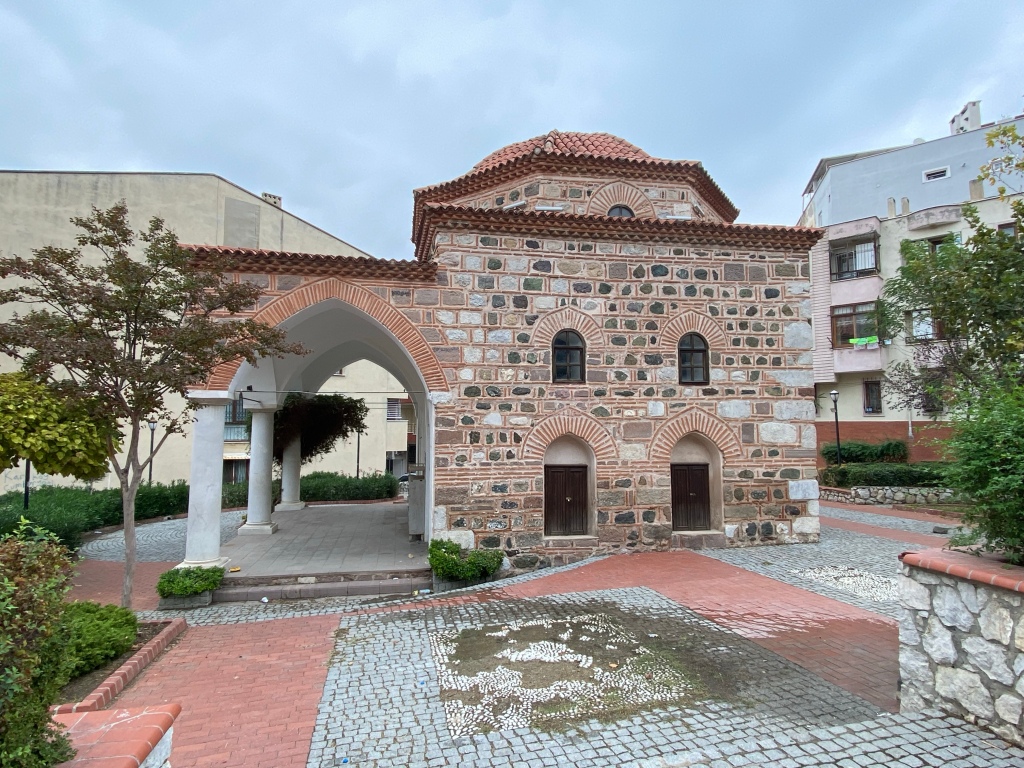
Foundation Stones of the Hamam of the Ottoman Palace located beneath the Giritliğil Hotel
We thought we’d treat ourselves to a treat and set off for the Muazzam Hamam as recommended by Asuman our very convivial hotel receptionist. Once inside we were given shorts and slippers and then spent a few minutes washing ourselves and relaxing in the traditional marble hamam. We didn’t opt for the body rubs and then spent 20 minutes in the sauna followed by a cold shower and another 20 minutes in the steam room. We finished off with another cold shower, a swim and another spell in the hamam. We were then given a peştemal (loin cloth), robe and head towel and enjoyed tea in a relaxation room. This was a great way to end our week.
Hamam Time
Later we had a couple of great shopping experiences. Did I actually write that? (Me being the man who hates shopping) The first was when we went into a Kuruyemiş (dried food) shop to buy some lokum (Turkish delight) and dried fruit. We all bought something but Cliff’s requirements were quite detailed and extensive. The two tezgahtar really enjoyed helping us out and as we paid offered us a taste of some of there other fruit-and-nut products. We left with quite a long queue of impatient locals wanting to buy their things!
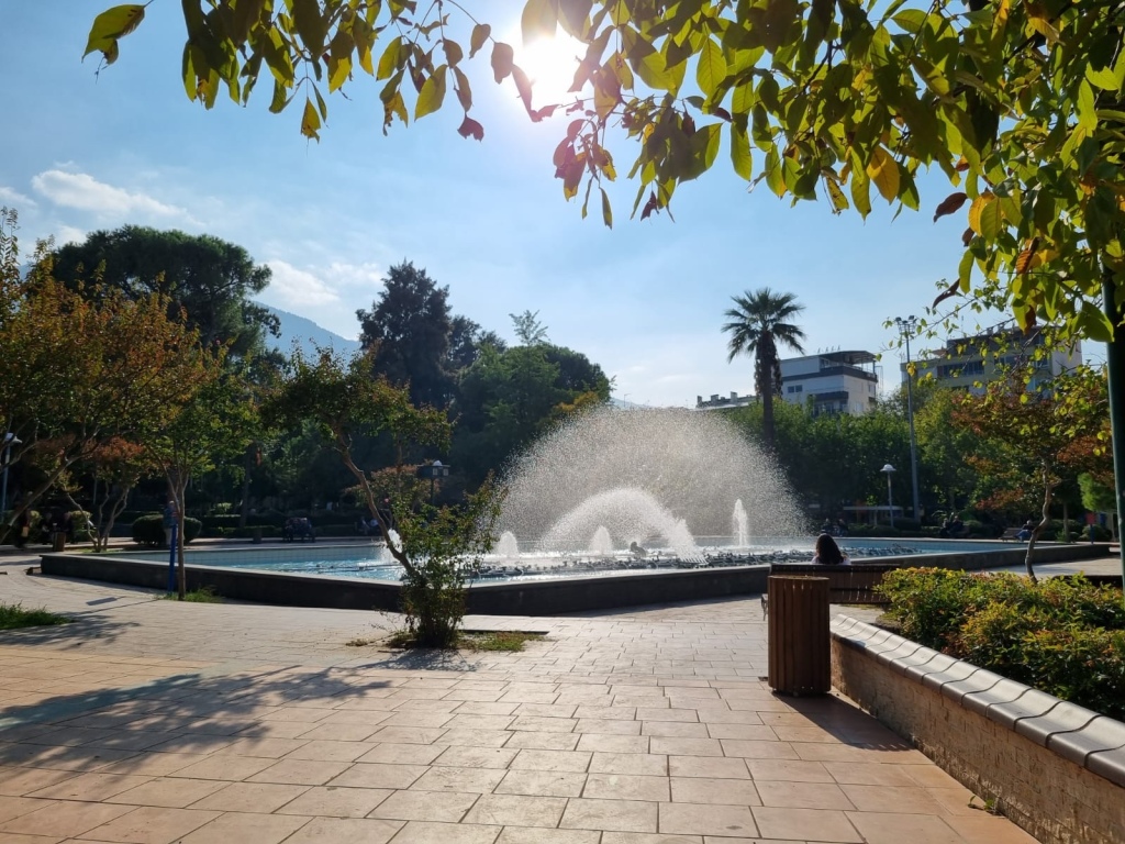
The Ulu (Noble) Park (One of the many parks in Manisa)
The second one was when we stumbled upon a herb and spice shop. Again Cliff had a list of specific requirements and a female customer (who was a friend of the shop’s staff) enjoyed helping us out. When we came to pay Cliff got a huge discount and the owner handed each of us packet of Manisa Manucu (a sweet paste) which is a local delicacy as a gift! The “shop friend” was thrilled by the fact that Cliff was a maths teacher like she was though of course Cliff had to prove her credentials by giving her a little arithmetical test! Which she passed!
It’s clear that the city doesn’t get many foreign tourists as everywhere we went we were a bit of a novelty and one chap who was watching some demolition works which we enquired about insisted he take a selfie with us.
After we called into our favourite cafe for the best coffee we’ve found we set off for the airport. We thought it would take just over an hour but it took nearer two due to congestion in Manisa and a bad choice of roads by me which got us snarled up in Izmir’s rush-hour traffic. We still had time for an earlier dinner in Gaziemir and made the airport with plenty of time to spare.
We enjoyed our best breakfast this morning. The usual Turkish offerings of cheeses, olives and vegetables but with a wider choice and supplemented with börek, fresh herbs and sweet pastries. As it was raining we enjoyed this at a very leisurely pace in the modern breakfast room built over the Ottoman Palace’s Haman’s wall’s foundations.
I’d planned a walking tour of the city based on the most popular sights. It was a mixed bag with a few disappointments interspersed with a couple of gems.
We walked out at midday heading west across the city for the archeological museum only to find it was closed for building works! Thanks again Google! However whilst there we got the opportunity to visit the nearby mosque (Saruhanbey Camii) which was opened in 2022 with its very elaborate interior decor.
Saruhanbey CamiiSaruhanbey Camii
We found a cheap local lokanta serving an excellent köfte. We then walked uphill passing an the Gülgün Hatum Mescedi and adjacent hamam to the ‘Weeping Rock’ (Niobe Kaya) which was a huge disappointment.
Gülgün Hatun Mescedi (prayer house)
A Greek legend has it that the rock was created when a women was turned to stone after her children were killed by the sons of the goddess whom she had angered. The rock was clearly a popular tourist spot but the amount of litter and detritus on and around the rock was atrocious and quite shameful.
Niobe Kaya and Full-Size Model for Scale. 😉
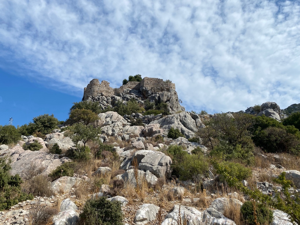
We then continued onto the remains of the walls of the old castle which has Byzantine origins and was used by the Ottomans. Little remains now other that a few sections of incomplete walls.
Manisa Castle Remains
We then walked onto the Sufi Mevlevi Lodge where we met a guide and also a scholar called Selman, who is a university teacher of Ottoman Turkish and Ottoman writing. (Ottoman Turkish was the language of the Sultan’s Court and Ottoman hierarchy and used a lot of Arabic words and Persian words and grammatical constructions. The common people didn’t /couldn’t use it and spoke a simpler language. As part of the language reforms many of these imported words were removed (some more successfully than others) and in 1928 Ataturk insisted that the Arabic script be replaced by a Latin script. This means that only academics and historians can read Ottoman Turkish).
Mevlevihane
Sufism is a philosophy that aims to reach God through the knowledge, reflection, art, enthusiasm and love under the guidance of the Quran and the Prophet. The well-known Sufi philosopher Mevlâna expressed this philosophy in Mesnevi which frequently refers to the verses of Quran and hadiths of Prophet Mohammed, and in his musical works which he performed with divine inspiration. Constituted by the disciples and followers of Mevlâna, the tradition of Mevleviyyeh is a historical variation of the Sufi philosophy.
Based on spirituality and intuition and also known as Islamic mysticism, Sufism and the Mevlevi tradition constitute the ideal theological and moral inclination of the Turkish Islamic thought after Gazali (a PersianSunniMuslim polymath). Generally in Sufism and particularly in the Mevlevi order, God is the absolute being and the absolute source of everything in the universe. The other beings are solely the manifestations of its being. Therefore, there is a “unity” between God and the rest of the beings; in other words, there isahdet-i vücud, ie a unity of being. The Mevlevi philosophy, in this sense, is a quest to be a part of this unity. According to the Mevlevi order, this unity can be achieved not only after death, in the next world, but also in this world through affection, love, and ascetic practices.
Mevlevihane information boards
Sufism was outlawed in Turkey in September 1925 by the new Turkish Republic under Atatürk. As a result, the Dervish lodge in Konya eventually became the Mevlana Museum. Though the Sufi lodges were forced to close down, Mevlevi practice continues within Turkey but in a more restricted and private mode. Sufism is still officially illegal in Turkey, and sema ceremonies are therefore officially presented as cultural events of historical interest rather than as worship. (Wikipedia)
We received a visitor certificate, tea and, as it was raining, a lift back down the hill to our hotel in Selman’s ancient battered Lada.
We ate again at the adjacent Taşfabrika restaurant and had a a bottle of very underwhelming red wine. We then strolled around the centre and called into a baklava cafe for çay and a selection of desserts.
After a beer or two on Monday night we decided that paragliding would be a great way to get a quick overview of the whole area and a much more efficient way than a hot air balloon ride. It’s funny how brave “beer goggles” can make you. 🙂
I spent over an hour that evening trying to book paragliding via an agency website and then by phone to someone on the other side of the planet somewhere. The transaction eventually failed and so in desperation I walked the whole five metres to reception and booked it there in person, in three minutes! And I did it all in Turkish!
We were all packed and ready to depart when the minibus arrived to collect us for the flights on Tuesday morning. We drove out of town to the drop zone where we collected one more customer and the four pilots. A 10 minute drive took us to the top of the mountain behind Hieropolis at approx 700m above sea level (the town is at about 200 m ASL) .
We moved to a different launching pad to get more benefit from the calm conditions. The twenty minute flights needs little description apart from the fact that it is exhilarating and not even a bit scary (despite the look on Cliff’s face below!).
Awaiting Take OffAbove Hieropolis Bob Above PamukkaleCliff Above The TravertineTouch DownAll Safely Down
Afterwards the pilots were very keen to sell the videos and photos (and consequently spent much of the time in-flight focusing on taking pictures of us) as this is how they really make their money.
Nevertheless you do get an amazing opportunity to see the ancient city and marvel at the travertine flows.
We departed from Pamukkale midday and drove to Manisa arriving at 4pm. This is another bustling and prosperous big city. Booking.com located us a very central 4 star hotel (Otel Giritliğil) and that night we ate in a converted pasta and flour factory next-door called Taş Fabrikası (Stone Factory). This had been built in 1890 by a Greek family (caller Giritliğil) and had had a complete high quality refurbishment in 2010 and has been used as a restaurant for the last nine years.
Taş Fabrikası Restoran
A short walk around the area in the cool evening air finished the evening off perfectly.
Faith Tower (currently under renovation – Cliff hiding the cement mixer quite well)
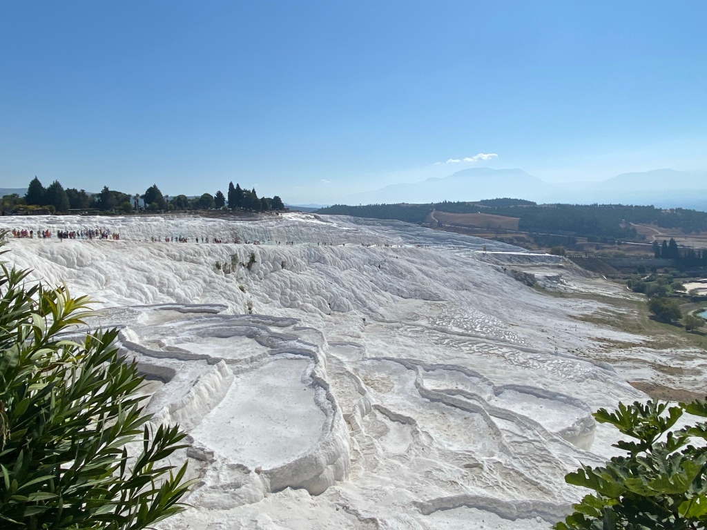
Pamukkale means cotton castle and this its name comes from its massive white terraces which are made of travertine, a sedimentary rock deposited by mineral water from the hot springs. In this area, there are 17 hot springs with temperatures ranging from 35 °C (95 °F) to 100 °C (212 °F). The water that emerges from the spring is transported 320 metres (1,050 ft) to the head of the travertine terraces and deposits calcium carbonate on a section 60 to 70 metres (200 to 230 ft) long covering an expanse of 24 metres (79 ft) to 30 metres (98 ft). When the water, supersaturated with calcium carbonate, reaches the surface, carbon dioxide de-gasses from it, and calcium carbonate is deposited. Calcium carbonate is deposited by the water as a soft gel which eventually crystallizes into travertine.
Breakfast in the rooftop terrace restaurant afforded splendid views oggling what Pamukkale had to offer. Spectacular pristine white rock formations and colourful hotair balloons ascended in the early morning sun. The entrance to the site was in walking distance,
We entered the travertine terraces from the south end and on arrival everyone has to take off their footwear and walk barefoot around 600 metres over the travertine. Some of us found this quite uncomfortable as the travertine was sharp in many places.
Pools had formed which were filled with hot natural spring water fed by the mineral-rich springs in the hills above.
On the Travertine
On leaving the travertine we entered the expansive Classical, Hellenistic and Roman city of Hieropolis which was used by the Byzantines. It had clearly been affected by earthquakes and was ultimately abandoned (like many other cities in the region) when the Seljuk Turks took over the region. It had been a very important city grown wealthy by wool and the healing powers of its thermal springs.
Byzantine Tower
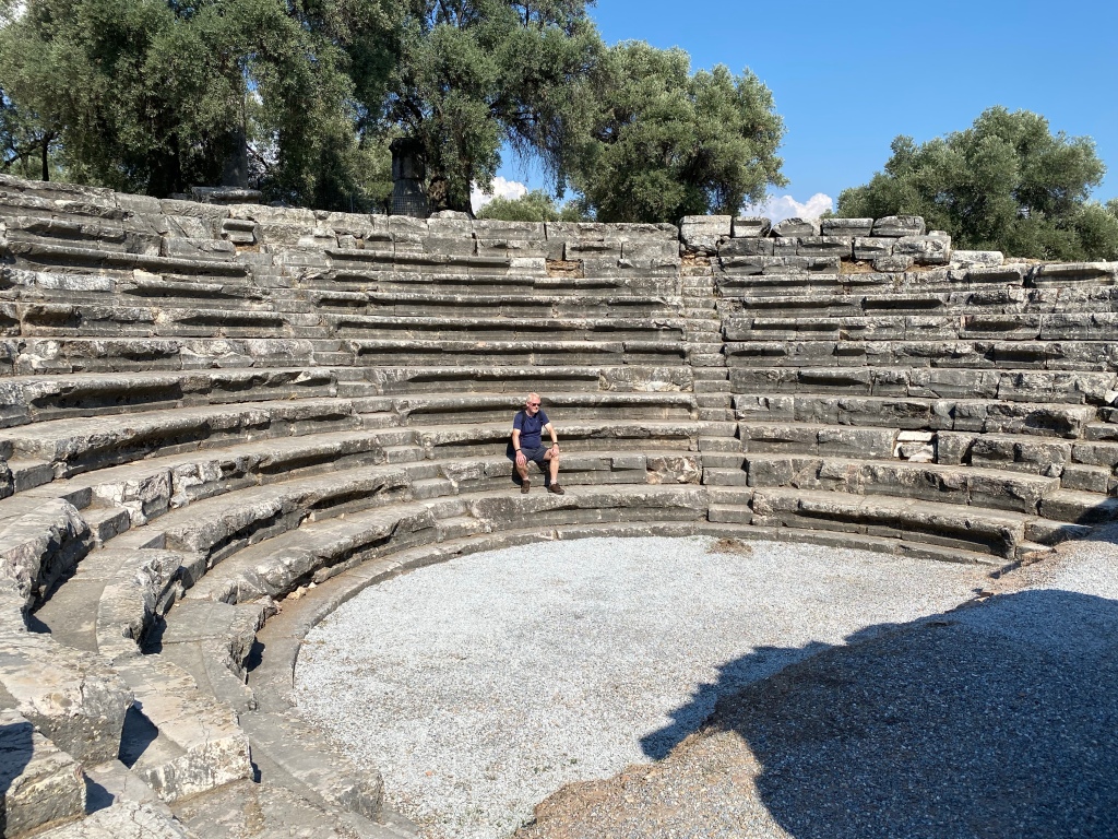
The city is remarkable for its extensive Necropolis, the highly restored amphitheatre and the temple of Pluto (The Plutonium), a fabled entrance to the underworld.
Travertine TerracesSarcophagi in Necropolis Old Northern Gates and Old Northern GitsNorthern Gate and SteetThe Temple of Pluto
The Plutonium. In the Augustan period (late 1st century BC) the rock face surrounding the entrance to the cave (which can be seen below in the above photo) was faced with a wall of travertine blocks, with Ionic semi-columns flanking the entrance to the cavity, from which lethal fumes of carbon dioxide were emitted and thermal spring waters flowed. The entrance to the cave itself is marked by an arch bearing the dedicatory inscription to Pluto and his bride Kore, the ruling divinities of the Underworld.
A key element of the sanctuary is the ritual theatre, built in a rectangular plan, from which about 800 worshippers could observe the rites that took place in front of the cave: the sacrifice of bulls suffocated by the gases and the entrance into the cavity by the eunuch priests of Cybele, the only ones able to do so without being killed by the fumes. The worshippers were forbidden to access the area in front of the cave.
Hieropolis Notice Boards
We had chance to experience one very real feature of the power of the thermal springs when we swam in the warm Apollo baths. If you inhale the air where the waters are aerated as they enter the pool the high carbon dioxide and sulphur content literally takes your breath away.
The Great Theatre and The Three Great Eaters2nd Century AD Statue of Triton (Son of Poseidon, God of the Sea)
We finished our day with a short 3km walk back to the town and walked into the Ala Turka restaurant in which we enjoyed a very convivial meze and güveç (stew), drinks and made plans for the next day.
Our first port of call was the museum in Afrodisias and following this we did a full tour of the ancient city of Afrodisias.
APHRODISIAS was a prosperous ancient city, famous in Roman times for its Sanctuary of Aphrodite. Its monuments are unusually well-preserved, making it one of the most important archaeological sites in Turkey.
A prehistoric settlement mound, later the site of the theatre, marks the earliest habitation of the site, in about 5000 B.C. By the 6th century B.C., the Sanctuary of Aphrodite was well-established, but Aphrodisias remained a village until the 2nd or 1st century B.C., when a new town was laid out on a grid plan.
The city occupied an area of just under one square kilometer, and had a maximum population of 15,000.
The Roman emperor Augustus took Aphrodisias under his personal protection in the late 1st century B.C., and the next 250 years saw the construction of most of the monumental buildings on the site. The city plan was centered around the Temple of Aphrodite and the Theater, with two large colonnaded squares between them. The Stadium, on the northern edge of the city, is the best preserved of all ancient stadia. Aphrodisias became the capital of the Roman province of Caria in the late 3rd century A.D., and was fortified for the first time in the mid-4th century. The city remained prosperous through the 6th century, when the Temple of Aphrodite was converted into a Christian church. In the Middle Ages, Aphrodisias was a small cathedral town, eventually abandoned in the 12th century.
(Afrodisias Information Boards)
It had a palm park which appears to be an unusual feature. Its basilica was not a church but a civic building and on its walls the maximum prices of all goods sold in this city (and across the region governed by the Romans) were inscribed in stone. Overcharging was punishable by death. Of note an African lion was worth five slaves!
Legal Maximum Prices ExamplesAfrodisias StatueThe Sebasteion in Afrodisias
Sebasteion means ‘great’ and it corresponds to the Latin word Avgustus which was originally a Greek word. There is no another Sebasteion in “the East of Roma” as particularly large and rich from the point of its reliefs. The structure is located on a main street, starting from the northern gate and ending at the theatre. Construction of this cult centre started during the reign of Emperor Tiberius and was completed during the reign of Nero (BC 54-68). The main structures of this cultural centre was demolished and rebuilt several times due to earthquakes.
Theatre Hamam (Bathhouse) The stadium (Hippodrome)
A combination of stylistic and historical evidence suggests that the Stadium was part of the monumental building program undertaken in the city in the first century A. D. The Stadium has a peculiar form in that it has two sphendonai (curved ends) rather than one. It is one of a small group of such stadia in the Greek world that epigraphical evidence suggests had a specific name: στάδιον ἀμφιθέατρον (“amphitheatral stadium”). The unusually complete archaeological record at Aphrodisias indicates that throughout the Imperial period the Stadium was used not only for Greek athletic competitions, but also for Roman spectacles such as gladiatorial games and venationes (animal “hunts”). In Late Antiquity a small stone amphitheater was built into its eastern sphendone, obliterating part of the Stadium’s running track. It is argued that this was a way of making permanent an arrangement that had always been temporary in past centuries. Gladiatorial contests had largely ceased by the time that the amphitheater was built into the Stadium, indicating that amphitheaters such as this one were intended not for gladiatorial games, as is often supposed, but for the venationes that seem to have flourished at the site well into the sixth century, long after they had been officially banned in all cities of the eastern Roman empire.
The Tetrapylon was a monumental gateway to the Sanctuary of Aphrodite built c. AD 200. It led from a main north-south street into a large forecourt in front of the Temple. Its decoration has a richness typical of the second century AD. The inner (west) façade is meant to surprise the visitor with its ‘broken’ pediment design and carved decoration that is even more extravagant than that of the outer (street) façade. A complete archaeological and scientific reconstruction (anastylosis) of the monument was completed in 1991. It was made possible by the extraordinary preservation of the structure as around 85% of its original marble blocks survive.
(Afrodisias Information Board)
We wondered how the city had become so prosperous and found out later that it was in part because of the quality of stone carvings which it produced using high quality marble from a nearby quarry.
We departed Aphrodisias at 4pm, driving cross-country, eschewing motorways for a mountain pass that took us up to 1400 m (from 700m) and through the town of Babadağ (father mountain).
The Drive Down from Babadağ
We arrived in Pamukkale at nightfall after a couple of failed attempts to find accommodation in less commercialised nearby towns. One room and breakfast for 2 nights at Kervansaray Hotel cost us just 3000 TL (ie £15 each per night). Although it was the end of season there were still a few restaurants open but the menus relected the touristy nature of the town. We settled on the most ‘authentic’ looking one “Ottoman House”. The pictures look great. The food was average at best.
We learnt that the archaeological museum in Aydın was worth a visit as it housed a lot of the best artefacts from Trellies and it certainly didn’t disappoint.
Statue of Pan
Pan, the Greek god of the wild, shepherds and flocks is recognized as the son of Hermes, the God of the shepherds of Arcadians, and Drops, or Hermes and Penelope’s son, sometimes the son of Zeus and Callisto or Zeus and Hydreis.
According to Homers, he cheered up all the gods and goddesses so he was given the name “Pan” which meant “all*. After his birth, Pan grew up quickly and his mother was scared to death after seeing him and ran away. However, Hermes took him to Mt. Olympos to entertain the gods, especially Dionysos. Pan who was the god of the Arcadians during the early periods spread to the whole Aegean world in time. Pan, the god of flocks, not only protected the wild and domestic animals but also he was a hunter. As the god of pastoral life, he played the pipe or the syrinx (pan flute) and was portrayed as a sensual being with a different body. Pon had goat’s feet, horns of a goat, and a small and tilted nose.
(Aydın Museum)
Statues from Trellies in Aydın Museum
Leaving Aydın, we set off for Nysa which hadn’t been on our original plan but the information about it at the Aydın Museum had whetted our appetites.
The ancient city of Nysa was an important cultural centre of Caria in Classical times. The site lies in the northern section of the Meander Valley facing Cevizli Mountain (Messogis), near Sultanhisar, 30 km south of Aydin. The city occupied a very important position within the ancient transportation hub between Central Anatolia and the urban centers of Caria and lonia, in the province of Asia of the Roman Era.
Several Classical writers tell us that Nysa was founded in the fertile Meander valley in the Hellenistic period during the third century
BC and quickly became a significant town as a result of intensive construction and civic activities during the Roman period. Historians of the Classical World such as Strabo (64 BC – 21 AC) and Stephen of Byzantium (6th century AC) say that Nysa, known originally as ‘Athymbria’, was a vibrant cultural center possessing several schools. It is known that Strabo, the most famous geographer of antiquity, studied there. In his monumental compilation entitled Geography (Geographica XIV, 649) Strabo speaks of Nysa as ‘a double-city , divided in two by a fast-flowing river and gives an account of its main buildings. The opulence and the prosperity of Nysa are still reflected today by the remains of the stadium, which was erected upon remarkable vaulted substructures on the slopes of the deep valley which cuts through the middle of the city, as wells by the three bridges crossing the river, the Agora, several tunnels, the theatre, the basilica and the city’s senate house.
(Nysa Information Boards)
Nysa Library
In the Classical and Hellenic periods libraries weren’t as we think of them today. They were private collections that could only be accessed by academics and scholars. It was the Romans who opened their libraries up to the public.
Theatre in NysaTheatre Stage in NysaStreet to the Agora in NysaSenate in NysaAgora (Market Place) NysaStadion (left) and 2nd Roman Bridge Remains (right) Tunnel Under 1st Bridge Carrying the Cakircak Stream
After Nysa we drove into Nazilli to find a better hotel (Otel Karin) and get a suite of rooms. It was a busy centre but more prosperous and bit more cosmopolitan then Aydın. We ate very well at the Şanlı Kebap restaurant YTL900 (~£9 ea) and then called in to our hotel bar for a nightcap and to listen to a live band doing covers of Turkish pop songs.
Leeds-Bradford Airport was relatively quiet and we breezed through baggage-drop and security.
I gave them both crayons and sweeties on the flight for being so good.
It wasn’t the best of flightsthough. I was seated midway amongst a group of about 30 very noisy Geordies who seemed to spend the whole flight shouting and throwing things at each other. Bob and Cliff were towards the front and were seated amongst families with young noisy children. Thank goodness for noise cancelling headphones!
The hire-car pickup at Boycar was quick, efficient and painless. We filled up our Dacia Sandero but couldn’t easily locate our hotel thanks to the inaccuracies of Google Maps and Booking.Com thus spent half-an-hour hour driving up and down the same stretch of dual carriageway trying to find it. Calling the hotel we discovered it was about two miles away in the town we’d already driven through.
This is Day 1 of our 2023 tour. Unfortunately the site at Trellies near Aydın was closed to visitors due to on-going archaeological excavations. Even so we went to the entrance hoping to meet some of the archaeologists and blag an unofficial tour from them. This has actually worked for us in the past! We were out of luck this time though as they were all on holiday. There were just a couple of very young soldiers guarding the site and they wouldn’t even let us stroll around the perimeter fence. Slightly disappointed we dropped down into the village of Kemer for lahmucan and ayran and then set off on a walk around the hills surrounding Trellies.
The city was founded by the Thracian tribes, the Thracians, and the Argos from the Peleponnes peninsula of Greece after the Doric migrations. Tralleis had to deal with wars and earthquakes and was renewed with the help of emperors. However, the economic center of gravity changed due to Istanbul being the capital and the trade of Tralleis was negatively affected. The city, which was physically transformed by Arab invasions, was conquered by the Turks in the 13th century and under Ottoman rule in the 15th century.
The 480-acre settlement area on the eastern slope of the city is within the borders of the military. It is known that civil and official architectural structures such as theater, stadium, temple and mint are also within the boundaries of this area. In addition to these, structures such as gymnasium – bath complex, church, villa and necropolis were unearthed during excavations. (www.visit Aydin.com)
Passing through the northern part of Aydın we discovered some unidentified remains of what we thought were possibly a Byzantine cistern.
We were walking in thirty-degree heat though the humidity was very low so it wasn’t that uncomfortable. As we crossed a side road stopped at a village tea-house and became a a novel side show for a couple of dozen locals who were all playing okey which is a popular board game in Türkiye (as we are now supposed to call it).
Climbing up into the hills around Danışmemt we lost the trail a few times and had to back-track then it suddenly went almost vertical and we had to resort to scrambling in quite a few places. We had some great views at the top but the descent failed to give us good sightings of Trellies unfortunately.
Cistern in AydınTaking in the Views near DanışmentUnidentified Supporting Structure North of TrelliesLong Distance View of Trellies Gymnasium Entrance (one of the few remaining structures) Trellies Gymnasium Entrance (copyright İhsan Tüfekçi, http://www.destinationsturket.com)
In the centre of Aydın we checked into a local basic hotel which (including breakfast) cost us £15 each. We had a walk around the pedestrianised centre and enjoyed a cool Tuborg and then an excellent choice of local dishes in a locanta. Poor WiFi and dysfunction from fatigue prevented me posting my blog.
The trails were much tougher than we expected hence the distances we covered were much shorter than we are used to walking. We’re fairly experienced walkers and have completed the Three (Yorkshire) Peaks, the Pennine Way, Wainright’s Coast to Coast, the Cleveland Way, part of the Lycian Way and dozens and dozens of day walks. We’re used to doing 20 to 25 km per day and up to 50 km when required but some days here we only managed about 12 km. Despite what’s reported elsewhere the way marking isn’t good enough on its own and a GPS is really a necessity. In many places it’s steep, loose and rocky and we found ourselves on hands and knees or scrambling in many places. My advice would be to take the lightest pack commensurate with your comfort needs, walking poles and very stout boots. I honestly think walking in this terrain in shoes is folly. It’s not the sort of place you want to find you’ve rolled an ankle as recovery isn’t probably and option on most parts of the trail.
We picked a good time of year and I’m sure late June, all of July August abad September would be too hot. The camp sites we saw had no facilities at and in effect you’d be wild camping. Also food and water supply point would need to be planned should you be doing through-walks.
I loved the remoteness of the places the trail took us through though. The remains of the buildings which we saw of course had none of the scale or grandeur of the later Greek and Roman sites we have visited and require more imagination to appreciate but we’re still very impressive given the period they were built in and the available technologies.
To summarise I’d say it’s a fantastic hard-core hiking route and not one for the inexperienced, unfit or casual walker.
Memduh and Sude Keleş (Boat Captain and Chef)The “Racing” GületsNot our boatThese are the type of flying fish we saw
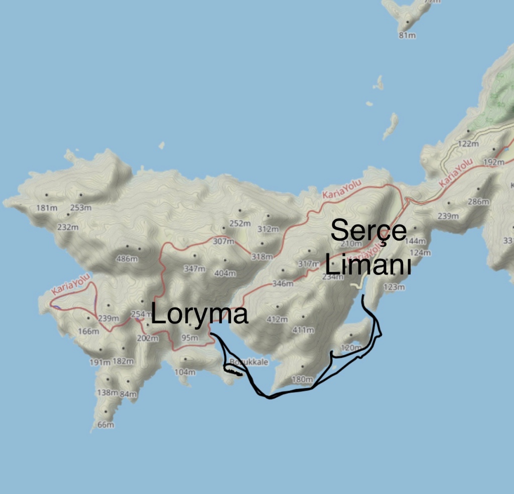
Serçe Limanı to Loryma Tuesday 11 October
Apologies again for the lack of information on our progress and status and photos. It got even worse this evening as we’ve had four power cuts and each one last from 5 to 30 minutes.
We played a master stroke this morning. This is where our single-mindedness pursuit of academic interest and archaeological knowledge came to the fore. After our disappointment at not getting to Loryma yesterday we drove down to the port at Serçe Limanı and drowned our sorrows in Ayran (the Turkish yoghurt drink). Whilst there were toured the small harbour where a few flashy yachts were moored and noted a couple of small motor boats which were advertising boat trips to the nearby bays … and one of these was the bay where Loryma is located. A little bit of negotiation ensued and we had a boat tour booked for the next day, ie today. Result! I hasten to add the decision to take the boat was in no way connected to anyones wish not to do a tough walk today. 😉
We had a minor hiccough on the drive to the port this morning. We got flagged down by a chap whose motor scooter had broken down and who wanted a lift to Söğüt to draw out some cash from the bank. He seemed a bit frail and had great difficulty putting on his seat belt. So I jumped out of the car to get to the other side to release the trapped belt and give him a hand. The most surprising thing about this was his insistence at using a belt given most Turks attitude to road safety. (We’ve come to the conclusion that mobile phone use whilst driving us compulsory as it’s ubiquitous.) The other thing that surprised me was his age he was 65 but seemed like an infirm old man alongside us. He claimed he was still working as a fisherman though.
As we dropped him off I noticed that one of my walking socks was missing off the back seat and so we had to make a return journey of a couple of miles to successfully locate it where we’d picked him up.
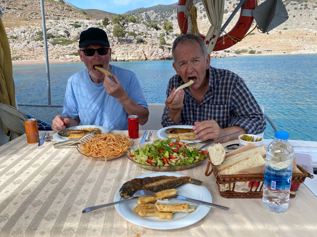
Memduh and his wife were waiting for us and we were soon on board and leaving the very sheltered harbour of Serçe Limamı (Sparrow Port). First we anchored at Korsun Körfezi (Pirate’s Bay) where we indulged ourselves with a swim w jete we spotted some flying fish. This was followed by an excellent if slightly more modest Turkish breakfast than we’ve got used to this week.
A Somewhat Easier Route to Loryma
Then we chugged over to Bokukkale and on the way we were overtaken by a couple of spectacular Gülets which appeared to be racing each other.
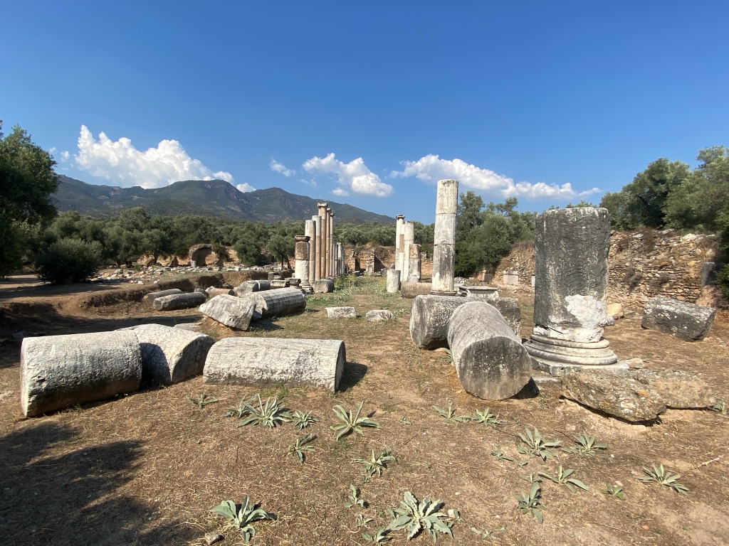
Memduh’s wife whose name I’ve ashamedly forgotten) tied up “Atabey K” on a pontoon below the remains of Loryma castle, which it located at the entrance to the bay, and we spent the best part of an hour exploring its remains. The walls were built on a prominent natural rocky outcrop which also provided a lot of the protection from the open sea-side of the the castle. Not much remains other that the blocks and some doorways of the lower section of the walls. It must have been a massive structure in its day because the walls measure around 300 m long by 40 m wide. There were no signs of any decorative carvings or written inscriptions anywhere though I estimated that many of these blocks had lost at least one cm from their thickness in parts due to erosion. However we did find another rock that had been carved out into an olive oil processing bowl.
Olive Processing Stone at Loryma CastleLoryma Castle Tower with Bozukkale Bay to the Rear
After exploring LoRoma Castle we motored into the Bozukkale Bay and went for a swim. Just at the rear of the shore of the bay were some more low stone walls which looked like they could have been the remains of another smaller fortress but probably of a different (later?) period. Bob and I swam to shore and scrambled around and over some rocks to get up to them them but we didn’t want to risk damaging our cameras so we’ve no photographs to show for it. We then swam all the way back to our boat which took us about 15 minutes as it was about 270 m away. Bob used his sandals as flippers and I was concerned about sunburn on my unprotected pate. So, ever the improviser and whilst in the water of course, I whipped off my swimming shorts and used them as a hat until I got back to Atabey – much to the amusement of Cliff and Kaptan Memduh. And I did put them back on before I got back on board.
Back on board we had a lunch of local fish and salad. The tastiest part was the “flute fish” which I think we call a trumpet fish. Memduh told us the other was a Lokum Balağı (brushteeth lizardfish) but we haven’t been able to verify this and it seems unlikely too.
Later, we spotted a lone figure on the rocks behind the shoreline and Memduh told us there was a goat herder aged about 45 who lived alone there. There are no roads to the bay and the only access is via the sea or the goat tracks which we’d used the day before. It would probably take 5 or 6 hours to get to the nearest village if Taşlıca. The herder’s mother and father used to live in the hut with him but since the father’s passing the mother had moved to Söğüt. What an incredible hard existence that must be.
The above map shows the route if our boat trip and walk. On returning to our departure port we drove back to the villa and prepared our bags for the flight home before going out again for pide and lahmacun (both a sort of Turkish pizza).
Serçe Limamı Road to Loryma Monday 10 October
The plan today was to take the trail from just north of the road to Captain Nemo at Serçe Limanı and try to get to three ancient sites. The first is Loryma (also known locally as Bozukkale ie ruined castle), the second the abandoned village of Karamak and the third an abandoned church.
Out path up the hillside
The trail was another barely defined (but mainly completely undefined) steep climb up a loose rocky crag. It was very slow going and eventually we reached the peak of the first hill (at around 250 m above sea level) but this had taken us the best part of two hours. We’d made a late start (due mainly to another large breakfast) and it was clear that there was no way we had the time to get to the castle and back in daylight.
We ate some fruit and then started to look around the rock strewn area. There was an ancient well which had water in it at a depth of about 7 metres and a carved-out stone drinking trough.
Well and drinking trough in foreground. There was water at a depth of about 7m.
There were quite a number of large carved stone blocks strewn around and the remains of a wall and what was clearly some sort of building. Some of the natural rocks had been carved out into what seemed like processing facilities. We assumed (correctly we found later) that some had been used for processing olives into oil.
Oil processing rock
A second olive processing rock.
The other even more interesting rock was one which we have only been able to speculate about so far. It seems like it could have been used for processing animal (goat) hides or meat or (much less likely) washing hides or clothes. Like a rank amateur I forgot to scale this image below but the human-made part was just over a metre long and half-a-metre wide.
We also found a collection of pottery shards though of course we’ve no idea whether these were contemporary with the rock carving. At least I scaled these with a house key.
We then made our way back down the path that we’d come up. This time the route finding was slightly easier as there were a few more signs (paint marks on rocks) to show us the way.
I think it’s this way! That’s the trail they’re sat on.
We’d been out for almost 5 hours and I’m not going to embarrass any of us by admitting how many miles we walked but I’m sure it’s the slowest pace that I’ve ever made
On the way back to Selimiye we stopped at Bozburun to have a look around the gület building boat yards. It seems as if the basic structure of these boats hasn’t changed for hundreds of years and the skills of the boat-builders was very evident.
Gület Under Construction
Taşlıca to Phoenix (Finike) Sunday 9 October
Finding somewhere to get a proper breakfast in Soğut this morning was challenging but eventually it came good with the Palamut (bonito) restaurant.
A lot of people in this area are just scratching a living out of the land and have very hard lives. We saw this elderly lady (and others) carrying what appeared to be animal feed long distances on foot.
When we walked into the Palamut Restaurant we were greeted by a teenager who seemed half asleep and and very vague about what was on offer so we had to wait a while for it to appear but we were eventually served with a vast array of typical Turkish breakfast dishes.
The donkey is still a favoured mode of transport of some of some of the villagers on the Bozburun Peninsula.
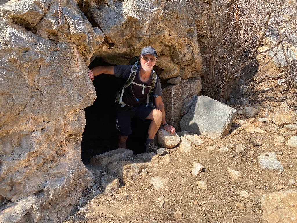
Whilst we explored Phoenix, from some distance I saw what appeared to be a cave but once we’d climbed up to it we realised it was some sort of ancient tomb or possible temple.
View from inside the tomb.
This is part of the location and ruins of the town of Phoenix (Finike in Turkish) which was part of the Rhodian Peraea or Peraia which was the name for the southern coast of the region of Caria in western Turkey during the 5th–1st centuries BC, when the area was controlled and colonized by the nearby island of Rhodes.
During the Hellenic Period the extent of the Peraia grew with the addition of various vassal regions. It reached its greatest extent in 188 BC, when the entirety of Caria and Lycia South came under Rhodian rule, but when Rhodes submitted to Rome in 167 BC, this region was lost again.
Can you see a path here? No? Well neither could we and this is quite typical of many parts of the Carian Trail.
View of the coast whilst returning from Taşlıca
The nearest town to Phoenix is called Taşlıca which means stoney-place-person . The whole area is just strewn with rocks and the soil conditions appear very poor. However to the south west of the ancient Phoenix settlement there is a fertile valley which is still used by herdsmen and “market gardener” type villagers.
All the cows in this region are of a very small breed.
We discovered this interesting carved stone in the lower levels of the Phoenix settlement.
Today’s route. Unfortunately we had to do an “out-and-back” as we did t have time to do a circular route.
Gülets at sunset on the shore at Denizkızı near Söğüt.
Marmaris Castle and Museum Saturday 8 October
We took a bit of a beasting yesterday and so we decided to have an easier day today and visit the castle and museum in Marmaris. We’d heard horror stories about Marmaris having been ruined by hordes of British tourist though the parts which we visited, around the old town castle, weren’t that bad and just looked like most other Turkish resort towns.
Marmaris Castle
We were a bit disappointed with the castle as it’s not much more than a tower or keep really and it’s been restored in what seemed to be (in parts) a Disney-esque style. However the museum was very interesting and they had artefacts and finds from 480 BCE including the Archaic, Classical, Hellenic and Roman periods.
Marble Head from Hellenic Period
We had a tour of the Kapalı Çarşı (covered market) and enjoyed a cheap but excellent lunch in a local lokanta before we headed back to Selimiye for a swim in the sea. Our returned was marred somewhat by a huge navigational error (mea culpa) when we missed the turning for Bozburun/Selimiye and found ourselves halfway down the Datça peninsula before Cliff noticed it.
Covered Market
We’d been invited by our villa hosts to use the beach facilities of a local hotel (which had been paid for by our hosts) but when we turned up we didn’t get a very warm welcome as they said they’d closed a few days earlier. So we went to a local public beach and enjoyed a quick dip before dinner.
Now that’s what I call a wrong slot! Last night’s mezelerAmphorae in the MuseumOttoman HeadstonesTour of the Old TownHands from a Bronze Statue (upper centre right)
Selimiye to Bayırköy Friday 7 October
The day started very well with a full Turkish breakfast at Delice in Selimiye.
The walk began with a gentle stroll along the harbour.
Very soon we were off the road and climbing up to the nearby castle.
This is the castle just outside Selimiye. There was no discernible track to the top. Cliff and Bob went up via the left side and I from the right. Both routes turned into scrambles over boulders and through bush.
Selimiye Castle was built by the Byzantines as a defence and to maintain control of the local sea trade route towards the Aegean Sea. Also it was used by the Byzantines (1204-1453) to maintain their feudal control over the local peasant population.
View of Selimiye from the castle top. Scrambling down from the castle
After climbing the castle we returned to the track which leads east towards Bayırköy. Through the day navigation ranged from easy to challenging to nigh-on impossible. In so many places there was no actually track and we were walking over scree, through boulder fields, over walls, crags etc.
Amongst some carved stones of an abandoned ancient settlement
The whole walk passed through a wonderful rocky landscape of scrubland and sparse trees. The route took us up to an area where there were some large stones and walls and we need to do some more research on this however it certainly looked pre-Hellenic.
Unidentified location on Carian Trail
The photos don’t give any indication of just how tough this walk was today. Almost every step we took involved lifting our feet and stepping onto or over large rocks and boulders. Much of the trail was over grown with large bushes and trees. There’s was a lot of steep climbing and descending and we were glad we’d brought our walking sticks with us. The shepherds had deliberately blocked off some of the route to coral their goats. Whist the route is way marked in places it was so easy to veer off it and lose the trail. It was very hard work and I’m almost embarrassed to say that our moving time only manage 2km per hour. I don’t think we’ve ever made such slow progress on any walk.
It was a lot steeper than it looks! We’d had to skip lunch because the walk took so long so we went for an early kebap supper at Şenol’un Yeri in BayırköyI seem to have yet another feline friend. We actually had a very heavy shower after supper
Selimiye to Bozburun Thursday 6 October
A late start was called for after the previous day of travel. Turgut called in to take payment and show us a around the town. Th breakfast recommendation was incredible – as was the price! It’s quite an upmarket resort which caters for the sailing market so prices and approaching UK levels in some places. This is not what we’ve been used to.
The view from our villaFeeding famished feline friends
We walked north east out of the town up a steepening jeep track. The late start meant we were in temperatures around 27°C. There is quite a lot of new building development underway on parts of the route in the area but fortunately most of it is low-level residential property. Once across a plateau the path into Bozburun was a steep rocky, technical descent which chose to use our walking poles on (or a makeshift one in my case). We ate a packed lunch on bench in shade alongside harbour in the town then to cool off we swam in the sandy bay which was ideal for cleaning off all the dust and dirt from the trail. A Dolmus back to Selimiye and a refreshing Efes in a beach bar followed.
From Selimiye (east) to Bozburun (west) The descent down to Bozburun
After a shower and cuppa at the villa we walked down to the village and ate at Fora Balik.
Plenty of cycling routes too.
The total mileage forge day was 10 miles with around 250 metres of ascent.
Sea food dinner at Fora Balık
Transfer Day Wed 5 October.
This was a fairly uneventful day that was hindered slightly by a couple of bad decisions.
We’re So Excited You’d Think We’d Never Flown Before.
Our 6am flight from Leeds Bradford left on time though once airborne none of us managed much sleep due to garrulous passengers (a pair of Gogglebox sisters and an inebriated middle-aged skin-head who almost missed the flight) . The car hire pick-up turned into a bit of an ordeal. There was no one to meet us and we eventually found that rental office was a few hundred metres away in the domestic terminal. Once we’d located it the clerk told we had the wait 30 minutes as the car hadn’t been returned on time. Then they wouldn’t accept my debit card as the rental t&c’s demanded it be a credit card. One of my credit cards had expired and the other one was declined. They wouldn’t accept payment from anyone else other than me as I was the original person who’d made rental agreement. Stymied! Another 10 minute wait ensued and the clearly eventually decided to accept my credit card even though they wouldn’t be able to take the full deposit. That debacle cost us a good hour.
The next bad decision was the choice of route from the airport down to Bozburun peninsula. I’d previously visited the area on a work trip about six years earlier and automatically used the roads I’d used then. These took us on a dramatic and spectacular coastal road but was so winding and twisty it cost us at least an hour.
Goats leading some old GOATs (Grandads On A Tour)
So we didn’t arrive at our accommodation in Selimiye until around 7pm. Fortunately our hosts Turgut and Meltem had provided us with some Gözleme (savoury pancakes), fresh fruit and tea do we didn’t need to go out for dinner. Well, we’d had a feast of köfte on the way down too.
Introduction
This is another of Turkey’s long distance footpaths. We’re aiming to walk some sections of it over the next week 5 to 12 October 2022.
The Carian Trail is an 800 km long distance walking path exploring Southwest Turkey through the modern provinces of Muğla and Aydın. The trail is named after the Carian civilization. On route you will discover a region rich in ancient ruins and history. Stone paved caravan roads and mule paths connect villages from the coast to a mountainous hinterland. Pine forest cloaks the mountain slopes whilst olive terraces and almond groves are an important part of the region’s economy.
The trail accesses a lesser known and unspoiled region that is full of colour and tradition for all to enjoy. The trail is signed and waymarked according to international standards allowing both independent and group travellers to hike and enjoy the scenic beauty and cultural treasures of Caria. A guidebook and a map is available, which gives the best detailed information about the route and region.
Most of our walking will be on the Bozburun Yarınadası (grey nose/beak peninsula).
The tail passes through the outskirts of Marmaris and resort of İçmeler then disappears twisting up into pine forested mountains.
The Bozburun peninsula is situated in the south west corner of Turkey, its wild and rugged beauty are a breath of fresh air after the mass tourism of Marmaris. The sparsely populated peninsula is home to less than twenty thousand inhabitants. The small town of Bozburun is the administrative centre of the region and famous for traditional boat building. Its sheltered bays and inlets are home to many craft during the winter months when they are hauled on land and propped up on wooden supports for repair and overhaul. In summer boats of all shapes and sizes can be seen at anchor or tied up at the harbor fronts all over the peninsula.
The top half of the peninsula is mountainous and forested with steep slopes rising from sheltered coastal inlets. Travelling south, the forest gives way to a barren rocky landscape with scattered ruins half submerged or hill top fortifications protecting hidden valleys’ and sheltered ports.
For the walker the remoteness is ripe for exploration. With a lack of roads the old trails and paths have been cleaned to access every viewpoint across the sea to the Greek islands of Symi and Rhodes. The Trail routes through a diversity of terrain with many changes of scenery and magical views round every corner. There are many traditional villages making a living from the rugged landscape along with coastal villages catering for the demands of tourism.